The Tropics Very Active with Bad Weather: Jamaicans on the Lookout! – See Graphs
As the tropical weather season progresses, meteorologists and weather enthusiasts monitor the skies for any signs of disturbances that could potentially develop into cyclones. Off the coast of Africa, a series of disturbances have captured the attention of weather experts, with some showing the potential to evolve into cyclones over the next seven days.
See the latest updated graph below:
Another graphical weather outlook shared online by @weatherjamaica a day ago provided an insightful snapshot of the situation, outlining five current disturbances and their respective seven-day cyclone formation chances.
The graphical outlook, a valuable tool for understanding and predicting weather patterns, showcases the disturbances’ locations and categorises their likelihood of developing into cyclones using a colour-coded system.
The key on the graph highlighted three colours, each corresponding to a specific range of probabilities for cyclone formation.
Yellow: A less than 40% chance of formation
Orange: A 40-60% chance of formation
Red: A greater than 60% chance of formation
Within this framework, two disturbances were marked with orange, indicating a moderate likelihood of cyclone formation. Meanwhile, two others were highlighted in red, signifying a higher probability of these systems evolving into cyclones. Additionally, another disturbance was labelled yellow, indicating a lower chance of cyclone formation.
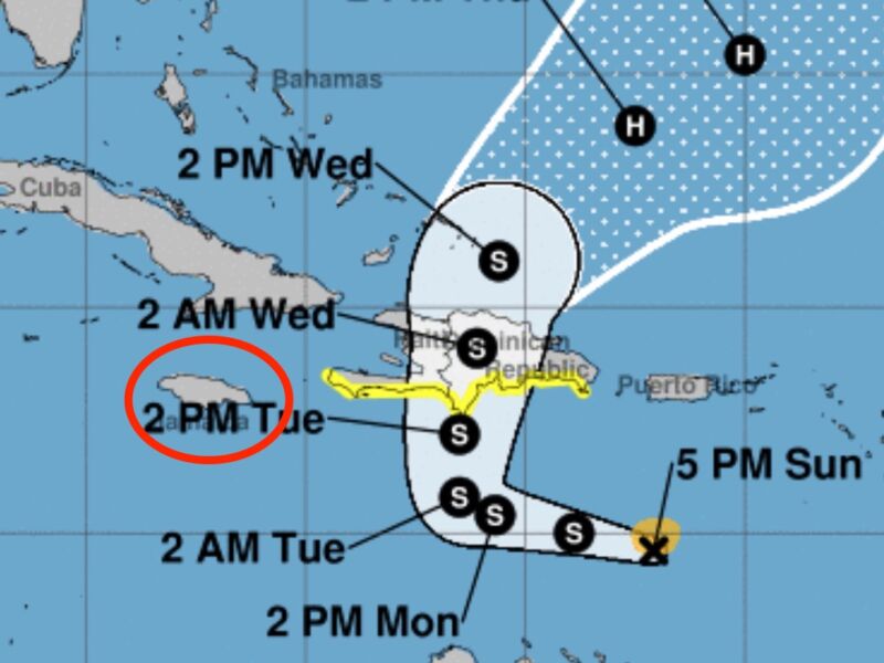
Of particular note was one disturbance marked in orange that appeared to be on a trajectory toward Jamaica. While meteorologists emphasised that weather patterns can be unpredictable and subject to change, residents of Jamaica are advised to stay informed and prepared in case the disturbance becomes a threat to the island.
See the photo of the graph below: